MAPPING
General
Out of all of the drone services on the market, drone mapping offers the most utility to businesses both large and small.
2D Maps are collected when a drone captures hundreds or even thousands of pictures which are then stitched and processed into a high definition map.
But you're probably wondering "why can't I use google maps", and you certainly can! It can take years for it to update and the the resolution will not be the best. However, using a drone will yield the complete opposite by providing you with a higher resolution map, the ability to update your map as often as you want, and can only be viewed by you.
These maps and pictures can help you and your team make rapid decisions by giving you a real world view. Data collection is very important in industries such as construction, infrastructure, aggregates, insurance, and environmentalism.
Check out this website for many types of examples of 2D mapping. https://www.dronedeploy.com/product/gallery/
Construction
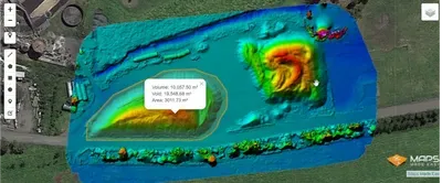
2D maps can help provide detailed updates on the progress of a construction project, since they allow you to zoom in and see different parts of the building's under construction, as well as related resources. When excavating mapping can also provide you with a accurate volume of how much dirt/aggregate you extracted.
Progressing on a construction project is the most important thing. However, there is a lot of management and investment that goes into each project. Instead of clicking through a bunch of pictures or worse leaving key managers or investors in the dark; a 2D map can be made quickly, can be viewed in one image that can be shared easily to your management team.
Real Estate
2D maps are being used in real estate to provide detailed, interactive maps of properties, which can help realtors to sell them. An 2D map made for real estate purposes could be of a small area, such as a house, or it could cover thousands of acres of property.
Typically they’re used to showcase large properties or estates, since it can be difficult to show a prospective client the entire piece of land and/or details of the buildings on the property when they are so spread out.
Conservation
2D maps can help conservationists in their efforts in a number of ways by providing a detailed, accurate map of the conditions in a given area.
Mapping forests and their growth, sand dunes and their movements, or the level of water in an area that houses a protected species of birds—these are all examples of how ortho maps are being used in the field when it comes to conservation.


